


Contour lines plugin — OsmAnd
OsmAnd
I found Contour lines plugin — OsmAnd most useful when a normal map is not enough. It is a focused add-on for OsmAnd Maps that adds terrain information through contour lines and hillshade, using SRTM, ASTER and NASA sources. In practice, that means the map can show whether a route climbs gradually, drops sharply or crosses a broad ridge before I commit to it. It belongs to the Travel & Local category, and OsmAnd is the developer behind it.
This is not a complete navigation app by itself, and that distinction matters. I see it as a specialist layer for people who already use OsmAnd and want a clearer picture of the land around a route. Hikers, cyclists, trail planners and travelers driving through mountainous areas can get meaningful value from it. Someone who only wants turn-by-turn directions around town may find the extra terrain detail unnecessary.
How the terrain information changes the map
Readability and navigation
The plugin’s main contribution is visual rather than conversational. Contour lines give the map a sense of shape, while hillshade adds light and shadow that make slopes easier to recognize at a glance. When I look at a route across unfamiliar ground, I can use the spacing of the lines as a quick clue: lines packed closely together suggest a steeper section, while wider spacing usually indicates a gentler change in elevation.
That can improve planning in a way a basic road map cannot. A route may look short on screen but cross a steep hillside. Another path may curve more widely yet be more comfortable because it avoids the sharpest climb. The plugin helps expose that difference before I leave, especially when the map view is zoomed enough to keep the terrain pattern legible.
Hillshade is particularly helpful when contour lines become visually dense. Instead of asking me to interpret every line separately, the shaded relief gives the landscape an immediate three-dimensional impression. I still need to read the map carefully, but the combination is easier to understand than contour information alone. For route planning, terrain context is often more useful than distance by itself.
Related News

Why WhatsApp Messenger Still Makes Everyday Communication Feel Easy

Jurassic World: The Game Is the Better Dino Tycoon for Strategic Players

Threads in Real Life: Who Should Join, Lurk, or Leave
How SHEIN Turned Shopping Into an Endless Content Feed
How to Make Fortnite Feel Smarter on Mobile

Should You Switch to Microsoft Outlook on Mobile?
There is a trade-off, though. Extra map detail can make a screen busy. Roads, trails, labels, route colors and contour lines compete for attention, and a display that is informative for a careful planner may feel cluttered during quick navigation. I would not leave every terrain layer prominent in every situation. For city walking, I prefer a simpler map; for a mountain route, I accept the visual density because the information has a clear purpose.
The plugin is most effective when I use it before navigation rather than treating it as a replacement for route instructions. I can inspect a planned line, look for sudden clusters of contours, and compare alternative paths. That workflow turns the map into a decision-making tool instead of merely a screen that tells me where to turn.
Supporting different ways of reading a map
People do not all read terrain in the same way. Some recognize elevation changes quickly from contour patterns, while others understand shaded relief more naturally. Having both styles available is valuable because it gives me two visual explanations of the same landscape. If the lines feel abstract, the hillshade can provide context; if the shading is ambiguous, the lines offer a more structured reference.
Gallery
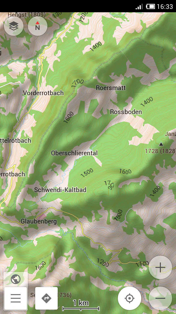
Text size and screen size still affect the experience. On a small phone, closely spaced contours can be difficult to distinguish, especially while moving. I get better results by pausing, zooming in and checking the route in sections rather than trying to interpret an entire region at once. That is also safer: detailed terrain reading belongs during planning or a stop, not while walking across a road or cycling.
Color and contrast are another practical consideration. Hillshade depends on differences between lighter and darker areas, while contour lines depend on their separation from the base map. Users who find low-contrast graphics tiring may need to adjust the map presentation or choose a zoom level where the lines are less crowded. I would not describe the plugin as automatically accessible for every visual need, but its layered approach gives users more than one way to understand the terrain.
For readers who rely on spoken guidance, this add-on has a more limited role. A contour line is a visual map element, not a spoken explanation of slope. It can support preparation before a trip, but it does not remove the need for clear route instructions or another way to confirm position. That distinction is important for anyone who cannot comfortably inspect a detailed map while traveling.
Motor and sensory considerations
The plugin does not demand complicated physical interaction once the map is configured, but reaching useful information may require several precise actions: opening the relevant map view, zooming, panning and comparing route sections. For someone with limited fine motor control, repeated pinching and dragging can become tiring. I find that planning a route in a calm setting is much easier than trying to make these adjustments outdoors in poor weather.
A sensible workflow is to prepare the map before departure. I would inspect the route while seated, zoom into the steepest-looking sections, and note where the terrain changes. That reduces the need for constant manipulation later. It also helps users who become overwhelmed by too many visual elements, because they can decide which parts of the map deserve attention before the trip begins.
Sensory conditions can change how useful the plugin feels. Bright sunlight may reduce the clarity of shaded areas on a phone screen, while darkness can make a bright map uncomfortable. Glare, rain on the display and gloves can all make map interaction harder. These are not failures unique to this add-on, but the terrain layer gives the screen more detail to interpret, so the effect is noticeable when conditions are difficult.
I also recommend treating the map as a planning aid rather than proof that a route is suitable. Contour spacing indicates the shape of the land, but it does not tell me whether a path is slippery, exposed, blocked or difficult for a particular mobility aid. A route with a modest elevation profile may still have surfaces or obstacles that the terrain layer cannot communicate. That is one of the most important limits to keep in mind.
For cycling, the plugin can help identify climbs that might be hidden by a road’s gentle-looking line. For walking, it can help compare a direct steep path with a longer alternative. For drivers, it may add useful context in remote or mountainous areas, although it should never distract from the road itself. In each case, the benefit comes from better preparation, not from staring at the terrain display continuously.
Situational access in everyday use
A realistic example is a weekend walk in an unfamiliar rural area. I might begin with a route that appears convenient, then notice a tight group of contour lines near the middle. Instead of discovering the climb after arriving, I can compare it with a nearby route that follows the slope more gradually. The plugin does not make that choice for me, but it gives me information that a standard street-focused map may hide.
Another useful situation is planning a cycling trip with different ability levels in the group. A route that is manageable for one rider may be uncomfortable for another, even if both can cover the same distance. Looking at terrain beforehand lets the group discuss where effort will be concentrated and whether a longer but gentler option makes more sense. I value that because it supports honest planning instead of reducing the decision to kilometers alone.
Travelers can also use the terrain view when choosing where to stop or which roads to take through hilly regions. It may reveal that two visually similar routes cross very different landforms. Still, I would combine it with local road information and current conditions. Terrain data can explain the shape of the landscape, but it cannot by itself confirm whether access is open or whether a path remains usable.
The plugin is less compelling for ordinary urban errands. If I am walking to a store, checking public transport or finding a café, contour lines add little and may make the map harder to scan. In those cases, the usual OsmAnd map without the terrain emphasis, or a simpler everyday navigation app, is likely the better choice. This is a specialist purchase, not an upgrade that improves every kind of trip.
It is also worth understanding the relationship with OsmAnd itself. Because this is a plugin for OsmAnd Maps, it makes the most sense for someone already comfortable with that mapping environment. If I only need a basic map and do not want to learn another layer-based workflow, the add-on may feel like extra complexity. Its value increases when I regularly plan routes where elevation and landform affect the decision.
Remaining barriers and practical trade-offs
The clearest barrier is interpretation. Contour lines are powerful once I understand them, but they are not self-explanatory to every new user. A first-time reader may see a dense pattern without knowing which sections represent a serious climb or how the map’s scale changes the meaning of the spacing. I recommend learning the basics in a quiet setting and checking a familiar area before relying on the layer for an important trip.
Visual clutter is the second barrier. The same information that helps an experienced map reader can compete with labels and route markings. This is especially relevant for users with visual fatigue, reduced contrast sensitivity or difficulty tracking several overlapping patterns. I would use the layer selectively, zoom in when necessary and return to a simpler view when following ordinary streets.
The price also affects the decision. The listed price is $38.99, which makes this a serious purchase for a narrow purpose rather than an impulse add-on. I would consider it worthwhile if I frequently use OsmAnd for outdoor route planning and genuinely need terrain detail. I would skip it if my trips are mostly urban, if I rarely examine elevation, or if I expect a complete navigation solution rather than a terrain-focused extension.
The app has an Everyone content rating, which fits its practical mapping purpose. It has been available since Dec 22, 2012, and the plugin has reached over 100 thousand installs. Its average rating is 3.8 from around 2.2 thousand ratings, with roughly 40 written reviews. I read those figures as signs of a specialized tool with a meaningful audience, not as evidence that it will suit every OsmAnd user.
One subtle trade-off is confidence. A detailed terrain map can make a route decision feel more certain than it really is. I have to remember that topographic context is only one part of accessibility and safety. Surface quality, weather, navigation errors, fatigue, mobility needs and local restrictions can matter just as much. The plugin improves what I can see; it does not guarantee that what I see is the whole story.
Compared with a standard navigation app, this add-on offers more useful terrain awareness but less immediate simplicity. Compared with a dedicated outdoor mapping workflow, it may be convenient for OsmAnd users who want the information integrated into their existing map. The best option depends on whether I value a single familiar mapping environment or prefer a tool built specifically around outdoor route analysis.
An inclusive verdict for the right kind of traveler
After using it as a terrain layer rather than expecting it to be a full navigation product, I see Contour lines plugin — OsmAnd as a focused and potentially valuable addition. Its strongest quality is that it makes elevation and landform visible during route planning. That can support hikers, cyclists, travelers and groups trying to choose routes that better match different energy levels or mobility needs.
I would recommend it to an OsmAnd user who regularly travels beyond flat city streets and is willing to learn how contour patterns work. I would especially consider it for people who prefer visual planning and want to compare steep direct routes with longer, gentler alternatives. The combination of contour lines and hillshade gives more than one way to read the landscape, which is useful when one visual style is difficult to interpret.
I would not recommend buying it solely for casual navigation, and I would not treat it as a substitute for route information designed around spoken guidance, surface conditions or accessibility details. Users who need minimal visual complexity may find the added layer tiring, while users with limited dexterity should prepare routes in advance to avoid repeated map adjustments in the field.
My practical advice is to test the planning method on a familiar route first. Look at the contour spacing, compare it with the actual slope, and decide whether the display helps you make clearer choices. If it does, the plugin can become a useful part of an OsmAnd-based outdoor routine. If it only makes the map busier without changing your decisions, the price is difficult to justify.
Overall, this is a specialized tool with a clear purpose. It does not try to solve every navigation problem, and that narrow focus is both its strength and its limitation. For the right traveler, the most inclusive benefit is better preparation: seeing demanding terrain early and choosing a route that fits the people using it. For everyone else, a simpler map may remain the more comfortable and practical choice.
FAQs for Contour lines plugin — OsmAnd
What is the Contour lines plugin for OsmAnd?
The Contour lines plugin is an optional OsmAnd feature that adds elevation information to the map. After installing the required terrain data for a selected region, it displays contour lines, elevation shading, and related topographic details. This is particularly useful for hiking, cycling, mountaineering, trail planning, and understanding how steep or mountainous an area may be before starting a journey.
Does the Contour lines plugin work offline?
Yes, the plugin is designed to work with downloaded offline map and terrain data, so you can view contour lines without a mobile internet connection. However, the data is not automatically available for every location. You normally need to download the appropriate regional terrain or elevation files in OsmAnd first, which can require storage space and an internet connection during the initial setup.
Is the Contour lines plugin free to use in OsmAnd?
Availability may depend on your OsmAnd edition, account, and current subscription rules. In some versions, contour lines and terrain information are included with OsmAnd Pro or another paid feature package, while access can differ between the standard Android, iOS, and promotional versions. Check the plugin page and purchase details inside the official OsmAnd app before downloading additional data.
How much storage space does the plugin require?
The plugin itself is usually not the main source of storage usage; the downloaded elevation and contour-line data occupies most of the space. Requirements vary according to the regions selected and the level of detail provided. Small areas may use relatively little storage, while countries or large hiking regions can require considerably more. It is best to review the download size before confirming installation.
Who should consider installing Contour lines for OsmAnd?
This plugin is most valuable for people who rely on terrain information, including hikers, trail runners, cyclists, climbers, backpackers, and outdoor photographers. It can help identify ridges, valleys, passes, and steep slopes when planning routes. Casual city navigators may not notice much benefit, since contour lines can add visual complexity and provide limited value during ordinary urban driving or walking.
Pros
- Adds detailed contour lines to hiking and outdoor maps.
- Works offline once the required map data is downloaded.
- Useful for judging slopes
- climbs
- and terrain difficulty.
- Integrates smoothly with OsmAnd’s navigation and map tools.
- Helpful for planning routes for hiking
- cycling
- and skiing.
Cons
- Contour data can require significant additional storage space.
- Coverage and accuracy vary depending on the selected region.
- Map rendering may become slower on older devices.
- The plugin is mainly useful for outdoor and topographic activities.
- Some features may require the OsmAnd app’s paid version.


